 Site-index
Mortars
Inscriptions
Roofing
Paving
Architectural
Occupation-sites
Site-index
Mortars
Inscriptions
Roofing
Paving
Architectural
Occupation-sites
 Contents of Database
 The author's page
Identification of ancient quarries is notoriously difficult, mainly
because they are commonly obliterated by more recent quarrying. This
list therefore collects two sorts of sites which may be
relevant to identifying the sources of stone in the Roman period:
(a) outcrops and (b) quarries. Most of the latter are modern or mediaeval,
but are recorded in case some of them turn out to have an unusually long
history.
The order is geographical, mixing the two sorts of sites.
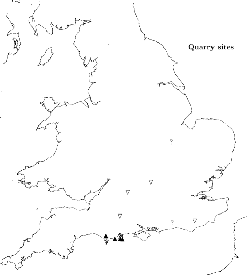
The map indicates only the main outcrop areas: solid triangles for
Purbeck Marble, open ones for other Purbeck Limestone, ? for
Sussex Marble and
Alwalton Marble.
Before 2003-12-12 this list also contained
occupation sites, which now appear in
a separate list,
which has the same order and subheadings as the present list.
© Copyright John Palmer.
This is work in progress, last updated 2017-12-29.
Please use this link
to send me comments and suggestions.
On the Purbeck monocline (E to W order)-
- name Peveril Point PM exposure
- cat Outcrop
- site Peveril Point, Swanage
- grid SZ 040 787
- publ Clements RG 1992
- desc Seacoast exposure of PM, type-locality for the Purbeck
beds (see table of Purbeck beds)
- subst PM
- comment I infer that the Roman army in its eastward movement in AD 43
would have first encountered PL here
-
-
- name Herston modern quarry site
- cat RB Occupation
- site Herston, modern quarry on Middle Purbeck, 1860 onwards
- grid SZ 021 783
- source Dorset SMR
- publ Calkin 1948 p.42,50
- publ Calkin 1953 p.69
- publ RCHM 1970 Dorset SE pt.3 p.612
- desc Inhumation burials and occupation débris from Iron Age A to late Roman;
IA A and C and Roman sherds, shale armlet roughs and cores. Several extended
burials in stone cists, Roman date. Cist with adult burial found c.1860
- loc Pottery in Poole Museum
- subst On Middle Purbeck
- date Roman
- comment see also
Priest's Caravan Park in
Occupation and
Uninscribed sections.
-
-
- name Wilkswood NT property
- cat Outcrop
- site PM quarry complex in Langton West Wood and Talbot Wood
- grid SY 994 796
- source visited 2002-08-12; ponds in wood on OS map
- source National Trust SMR
- publ Papworth 1994b,
in National Trust SMR
- publ Treswell R 1585
- publ Woodward W 1775
- publ Forrest and others 2017
- desc
PM and Burr quarries S of Wilkswood Farm;
NT site nos.112,364 and 112,794.
(NT SMR gives grid-refs SY 990 795 to SZ 000 793, which line does pass S of the farm, but extends much further W and E.)
Workings, now overgrown with woodland. NT no.112,364.
The western part, which forms
the northern part of Langton West Wood, has a stream running through; also
ponds, shown on 1888 and 1929 6in and recent 1:25000 OS maps but mostly dry
at my visit.
Some of the water channels esp. at the W end look artificial.
Red soil, thought to be due to weathering of PM or PL.
PM fragments, sample taken.
L. West Wood contains some dry stone walls, which continue in at least
one place as a bank. NT notes that a section of wall at SY 9910 7455
has stones pitched at 30 deg. to horiz. and seems to mark the S extent
of the quarry area. JP found wall with stones so laid 2002-08-30 but
found that quarried area does extend S of this: took Sample of
gastropod limestone from a large pit S of the wall.
2002-08-12 JP noted signs of recent scraping clear of some of the hollows
in the floor of the wood. Langton West Wood includes oak, ash, ?birch,
holly, and hazel (coppiced). Many rotten and fallen oaks show its age.
NT archaeological assessment 1994
describes the wood thus: oak and ash standards with occasional field maple
... N part of Langton West Wood has many ancient coppice stools;
the S part seems to have been clearfelled and replanted with hazel and
deciduous standards. Talbot Wood has hazel coppice, and mature oak at its
E end. The woodland at Wilkswood once extended further S, see fieldnames
`Cut Coppice' and `Wood Close' in
Treswell and in
Woodward's C18 map.
Oddly, Treswell does not mention any quarries in Langton Wallis parish,
perhaps because they didn't pay rent to the landowner at the time; the
explanation may be in the Purbeck Marblers' Charter (held at Lloyds of London,
and something of a mystery).
The woodland was already present by the time
Treswell made his map.
The 1888 and 1929 OS maps show the N edge of the site, close to the E-W
public footpath, as unwooded, but the wood now includes the footpath
(correctly shown on OS 1:25000 of 1999)
and has now linked Langton West and Talbot woods to the N of
Wilkswood Farm.
NT says the footpath is the mediaeval road to Corfe Castle,
NT site no.112,791. (A local person met 2002-08-29 called it a
Roman road, but Good (1966)
identifies it as a mediaeval road,
Swanage High St-Oakridge-Valley Road-Quarr-Downshay-Afflington-Scoles Gate,
the last being at the SE corner of Corfe Common.)
The 1929 map shows a rectangular area (?enclosure) close to the S side
of that footpath which was not shown in 1888.
Trev Haysom
found a PM mortar
in Talbot Wood at SY 998 793 (say NT) which
is now in Langton Matravers Museum, who say it is medieval; NT no.112,795.
He also found Roman pottery under roots of a fallen tree (Martin
Papworth, pers. comm. 2003-08).
Mediaeval quarries appear as bowl-like pits; mining started C16.
In 1722, 600sq.ft. of rough stone was dug at Wilkswood (Bankes records).
- subst PM, PL
- date NT: mediaeval. However Roman pottery has been reported
(see description above). For antiquity of trees ask John
Winterbottom
- comment NT: Talbot Wood also called East Coppice
- comment NT: Stone cross of PM found on this site retained by Mr Walbridge
of New Barn Farm
- comment Very close to Calkin's 1941-2 site
- comment Calkin's bronze age
PM cist was in the area
- comment NT SMR contains recommendations for [1] a 1:500 survey to be made
of the quarries, stone walls and trackways in Langton West Wood and Talbot
Wood, with the positions and descriptions of mature trees; also to talk
with Mr R Saville, Curator, Langton Matravers Museum
-
- name Wilkswood presumed quarry site
- cat Quarry
- site Wilkswood, Langton Matravers, 1941-2
- grid SY 9937 7941
- source RCHM 1952, p.602 no.42
- source National Trust SMR
- publ Calkin JB 1942
- publ Calkin JB 1949, p.36
- publ Calkin JB 1954, p.52-3
- publ Calkin JB 1960, p.121-2
- publ Calkin JB 1968 p. 25-26
- publ Dunning GC 1949
- desc NT SMR: no.112,071
- desc RCHM: Occupation débris was found,
possibly connected with Purbeck marble industry and
possibly with shaleworking,
on the E edge of a modern quarry in the Purbeck marble outcrop;
most of the pottery was mid- to late 1st century AD,
with a few Iron Age A and late Roman ware.
- desc Calkin: ``Purbeck marble. Part of a slab 0.55in thick
(No.5). Both faces and one edge have been sawn. One face is polished,
and hase an incised line 2.7in from the edge.''
- desc Calkin 1968: Found by E V Higgins. About 4in by 3in and 1/2in thick.
One face polished, one sawn, the one unbroken edge also sawn.
- desc Calkin 1948 p.36:
``Whilst the C culture was spreading,
Roman prospectors were exploring the mineral resources of the district.
Within 100yd of the PM outcrop at Wilkswood, we find the familiar BB
wares, side by side with imported Roman pottery incl. early Samian,
pink and buff-coloured jugs, and amphorae. A polished slab of
marble confirms ... that these relics mark the site of one of the earliest
PM quarries. The discovery of finished products at
Chichester and
Colchester
proves that quarries were opened almost immediately after the Conquest.
Wilkswood has also produced shale articles made on the lathe,
but so far the earliest Roman workshope sites at Kimmeridge belong to
the following [2nd] century.
It is possible that clay workings at Creech and Fitzworth[?] passed
under Roman control at about this time''
- desc Calkin
supposes from the location that the site was occupied
for the purpose of working PM. ``.. appears to be connected with quarrying
of PM in the early years of the Roman occupation .. Site lies on E edge
of a quarry opened in 1930s by Mr George Lander [for] working the
burr stone [Clements DB220: JP ].
[ Is this the latest known quarrying of Burr-stone ? JP ]
A spread of C1 pottery, shale, animal bones,
daub, iron nails, slag, ec. suggesting a midden, extended over an area
5yd by 4yd. Numerous pieces of limestone seemed likely to be débris
from a building, but nothing was found in situ. Trial holes revealed
a thin scatter of similar pottery etc. extending E for 100yd. Out of some
2000 sherds, 5 .. Iron Age A, 2 were frags of flanged bowls, all the
remainder appeared to date from C1 AD .. '' [Includes imported material
of reigns of Claudius and Nero.]
- desc NT: condition in 1994: permanent pasture.
Remains of disused and part-filled quarries.
Recommended to preserve under grass, and to trace Calkin's
excavation records
- loc Material transferred from Christchurch Mus. to DCM, acc.2001.115
- subst Calkin: PM
- comment Calkin: ``[PM] is unworkable W of Orchard .. all the
marble quarries are in the 6mile stretch from Orchard to Peveril Pt''
- comment NT SMR says the remnants of
field systems S of Wilkswood, [?farm] buildings are of
Bronze Age to Romano-British date;
RCHM 1970 Dorset SE pt.3 p.632.
They do not overlap the present site. NT numbers 112,072 and 112,344
-
- name Primrose Hill, Langton Matravers
- cat RB Occupation
- site SW corner of quarry on N side
of Primrose Hill, E of Haycrafts and Downshay (or Dunshay) Lane, 1952
- grid SY 9871 7952
- publ Brown PA, in Farrar RAH 1952 p.93
- desc [Romano-British] Pottery found at depth 1ft in the
quarry face, but trial holes in S direction proved unproductive.
2 frags of Samian; most of a small coarseware jar 4in high, in frags,
a countersunk handle, an iron nail, and a bronze object (? split pin
or tweezers).
- desc Brown says ``may have been associated with PM quarrying
to the N of the site''. Site is 1/2miles NE of
Gallows Gore
Early Iron Age and Roman sites
- subst PM
- comment See also Dunshay Manor nearby
-
-
- site Dunshay (or Downshay) Manor,
Langton Matravers
- grid SY 9834 7974
- publ Farrar RAH 1966 p.120
- publ RCHM 1970 Dorset SE pt.2 p.413 ?
- desc PM fragments
- desc ``Road widening at .. Haycrafts Lane .. exposed a small area of
dark earth in the face of the cutting 3ft below the level of the field to the
W .. about 230ft above sea-level on the N slope of the limestone ridge ..
RB sherds, animal bones and .. iron slag .. noted by Mr PA Brown .. also a
class C shale core and a shale disc 3 1/2in diam with central hole ..
site close to PM outcrop (acc. to Geol Survey map the outcrop is 70yd
to the S) and some frags of this stone [PM] were seen in the deposit''
Conjectures RB marbling about here, close to known mediaeval quarry site
(Leach 1978)
- desc RCHM: present manor house built 17th century, partly rebuilt 1906;
presumed to be on the site of the mediaeval manor house
- desc Dorset SMR: overgrown mounds of PM waste extend E from Dunshay Manor,
no quarry face found. Earthwork visible on aerial photo to W at
SY 9202 7967
- loc ? DCM acc.2001.41 (DNHAS Ann.Rep.2001 p.12)
- subst PM
- comment See also
Primrose Hill nearby
- comment Occupied by
Mary Spencer Watson, sculptor
-
- name Gallows Gore (East)
- cat RB Occupation
- site Lander's Quarry, Gallows Gore
- grid SY 9817 7895
- source Dorset SMR
- publ RCHM 1970 Dorset SE pt.3 p.621
- publ Calkin 1953
- publ Calkin 1947b p.42
- publ Calkin 1948 p.40-41
- publ Calkin JB 1968 p. 32
- desc RCHM: similar to Gallows Gore West
but no pre-Roman shale workshop. ?Leather-working of Roman period.
5 stone blocks some 6' apart associated with shale-working débris; possibly
bases for lathes. 2 short lengths of drystone wall may have served the
same purpose. Elsewhere a small storage cist with a paved area adjoining
a short drystone wall was ?C3-4 date. Inhumation of child, in cist with
a handmade vessel prob. Iron Age A
- loc Objects in Christchurch Mus, BM and Calkin's own collection;
some transferred from Christchurch to DCM, acc.2001.127
- subst On Middle/Lower Purbeck
- date Roman
- interp Roman shaleworking factory
-
-
- name Gallows Gore (West)
- cat RB Occupation
- site Lander's quarry, Gallows Gore, Langton Matravers, 1931 onwards
- grid SY 9782 7901
- publ Calkin and Piggott 1938
- publ Calkin 1947b
- publ Calkin 1948,
p.40-42, 46-50, 53-54
- publ Calkin 1953 p.52,69
- publ Swanage Times 1954-01-20
- publ RCHM 1970 Dorset SE pt.3
- desc Iron Age to late Roman sites. ``Quarry digging has revealed 2 closely
adjacent prehistoric sites at Gallows Gore ... just N of the Swanage to
Kingston road. The W one, due S of Downshay Wood, has yielded more IA
relics than any site in Purbeck ... towards the middle of C1 after Christ
if not earlier, some of the inhabitants were able to afford ... bronze
jewellery ... 2 bracelets, a torc and a pin seem to be made in the native
tradition but some of the brooches are later and may reflect the prosperity
of the new marble trade''
- desc RCHM: Occupation continuous from late IA to late Roman. Roman phase
marked by storage-pits, a ?well, stone-lined, frags of burnt clay daub,
a few short lengths of drystone wall thought to be C2 or later, near which
were floor-slabs and
stone roof-tiles;
also 2 rectangular storage cists,
one of reused roof-tiles
containing 3 jugs of ?mid C2, and 3 shale-working
floors with ribbed and lightweight plain armlets, class C armlet cores,
and flint lathe-tools. Also ... RB brooches of C1 and C2, Roman coins
of C3 and C4, a pierced shale slab (in DCM, possibly a window-shutter),
and frags of crude pottery ?connected with salt trade.
- loc Objects in Poole Mus, Christchurch Mus, DCM and British Museum;
some transferred from Christchurch to DCM, acc.2001.127
- subst PL
- comment cited by
Dunning 1949
- comment quarry still in use; quarrying Middle Purbeck
- comment see also Roofing
section
-
- name Sheepsleights quarries
- cat DOUBTFUL
- site Worth Matravers, around eastern road from Langton
- grid SY 98 78 approx.
- source Reg Saville,
Langton Museum
- desc Quarries in the Downs Vein used (in modern times) for roofing
slats. Limestone split along bedding by frost. May be source of
Bucknowle roofing
(R Saville)
- desc See table of strata;
this is probably DB 114 in the type-section described by
Clements 1992
- subst PL
-
- name Blashenwell Tufa
- cat Outcrop
- site Blashenwell (Farm), near Kingston
- grid SY 951 803 or nearby
- source Arkell 1947 p.352-3
- publ Reid 1897
- desc Tufaceous deposit up to 8ft thick,
formed around spring and stream still existent,
flowing northwards on top of strata from Middle Purbeck up to Wealden,
and embedding rubbish of early Neolithic occupation,
without evidence of cultivation
- subst Holocene tufa
- date Mesolithic
- comment Possible source of tufaceous limestone for Roman industry at Norden?
-
- name Encombe Quarry Wood
- cat DOUBTFUL
- site NE of Encombe House, named woodland
- grid SY 951 789
- source so named on OS 1:25000 map
- desc not visited, private property
- subst PS or lower PL
- comment More enquiries are required to establish Roman use
-
- name Encombe old quarry
- cat DOUBTFUL
- site N of Encombe House, in woodland
- grid SY 947 793
- source marked on OS 1:25000 map
- desc not visited, private property; unless car-park occupies its site
- subst PS or lower PL
- comment More enquiries are required to establish Roman use
-
-
- name Bradle Barn quarry
- site Bradle Barn, Church Knowle
- grid SY 933 797
- source shown on OS 1:25000 map
- desc On side of dr N-S valley in Purbeck dip-slope;
massive limestone, sampled 2002-08-12. A field between this and the Bradle
Farm to Orchard Farm road has red earth (due to weathering of PM?)
- subst PL
- comment More enquiries are required to establish Roman use
-
- name Bradle Farm PM area
- cat Quarry ?
- site E-W road E of Bradle Farm, Church Knowle
- grid SY 936 806
- source personal observation 2002-07-29
- desc Road parallels PM outcrop with easy access on S side.
- subst PM
- date probably modern
- comment More enquiries are required to establish Roman use
-
-
- name Steeple Quarry
- site Steeple, about 1km SE of the village
- grid SY 915 802
- source marked on OS 1:25000 map
- desc Quarry in Middle Purbeck, including Cinder Bed, and possible
roofing stone, perhaps from Downs Vein. Samples taken 2002-07-29
- subst PL
- date probably modern
- comment More enquiries are required to establish Roman use
-
-
- name Worbarrow Tout PM exposure
- cat Outcrop
- site Worbarrow Tout, Tyneham, within Army ranges area
- grid SY 868 795
- publ Ensom PC 1984
- desc Seacoast exposure of PM and PL
- subst PM, PL
- comment adjacent to find-sites incl.
Frend's mortar and
Miles' quern
-
-
- name Bacon Hole PM exposures
- site Bacon Hole and Mupe Rocks, within Army ranges area
- grid SY 840 797
- publ Arkell 1947 p.139-140
- desc Seacoast exposure of PM and PL
- subst PM, PL
- comment beds greatly attenuated and folded
- comment More enquiries are required to establish Roman use
-
- name Lulworth Cove PM exposures
- site Lulworth, cove entrance, both sides and Stair Hole
- grid SY 825 797 approx
- publ Arkell 1947 p.141
- desc Seacoast exposure of PM and PL
- subst PM, PL
- comment beds greatly attenuated and folded
- comment More enquiries are required to establish Roman use
-
- name Durdle Door PL exposures
- site Man o'War Bay and Durdle Door
- grid SY 806 802 approx
- publ Arkell 1947 p.142
- desc Seacoast exposure of PL; PM missing
- subst PL
- comment beds greatly attenuated and folded, PM not found
- comment More enquiries are required to establish Roman use
North side of Weymouth anticline (E to W order)-
- name Holworth House quarry
- site W of Holworth House, near Burning Cliff (NT)
- grid SY 763 815
- publ Arkell 1947 p.142-3
- desc Exposure of PS and basal PL in fault-block,
where there has been modern quarrying of PS; similar PL strata to
Poxwell Quarry
- subst PS, some PL
- comment More enquiries are required to establish Roman use
-
- name Moigns Down pit
- site E of Poxwell, Moigns Down Barn, N side of Poxwell pericline
- grid SY 754 837
- desc Disused pit marked on OS 1:25000
- subst unknown, not yet visited
- comment More enquiries are required to establish Roman use
-
- name Poxwell quarry
- site Poxwell, on outside of A353 bend, at mobile phone radio mast
- grid SY 743 835
- publ Arkell 1947 p.144
- desc Small quarry in PS and PL, latter including a dirt bed with
tufa masses above; running E from it for over 100m a linear cutting
probably a quarry in PL and perhaps PS, all grassed over
- subst PS, PL
- comment More enquiries are required to establish Roman use
-
- name Poxwell West quarry
- site Poxwell, on inside of A353 bend
- grid SY 739 835
- desc Elongated quarry and hillside workings further W,
left of bridlepath from A353 to Pixon Barn
- subst Sample, looks like ?Portland Stone
-
- name Osmington Quarry and Pits
- site Osmington
- grid SY 730 834
- desc Quarry and pits beside bridlepath from Osmington to Pixon Barn,
shown on OS 1:25000
- subst probably PS, some chert. Sample, taken 2002-08-17
- comment More enquiries are required to establish Roman use
-
- name Osmington flooded pit
- cat DOUBTFUL
- site In meadow, beside footpath between Osmington and Sutton Poyntz
- grid SY 720 836
- desc Flooded pit, overgrown, in Kimmeridge Clay under Head,
acc.to Geol. Surv. map; Sample, of shelly limestone from NW side was
probably imported as make-up for farm track
- subst prob. Kimmeridge Clay
-
- name Boiling Rock pit
- site E side of Boiling Rock Reservoir, Preston/Sutton Poyntz
- grid SY 698 834
- desc Pit marked on OS 1:25000, not yet visited by JP
- subst probably PS Freestone series acc. to Geol. Surv. map
- comment More enquiries are required to establish Roman use
-
- name Chalbury Quarry
- site W side of Chalbury IA hillfort, Preston, Dorset
- grid SY 693 837
- desc Quarry in Portland Freestone and Cherty Series with PL above
- subst mainly PS with some PL
- comment More enquiries are required to establish Roman use
-
- name Great Upwey quarry
- cat Quarry, Outcrop
- site Ridgeway above Upwey
- grid SY 671 852
- publ Arkell WJ 1947 p.116
- publ Fisher O 1856
- desc Arkell: `beneath thick Purbeck beds, 19ft of Portland Stone can
be seen, the whole of it belonging to the Freestone Series, although
there are more bands of chert than usual'.
- desc Large Quarry, adjacent to the line of the Roman road
from Dorchester to Radipole, on the southern or scarp face
of the Ridgeway. Now farm land (grazing), no public access.
- desc Fisher says that at the Ridgeway,
Purbeck beds go up to the Upper Cypris Shales incl. the Marble;
his Ridgeway section was measured in the railway cutting
(Damon 1884 p.124),
which is close on the East to this quarry
- desc Visited by David Weber, Peter Nevill and JP, 2003-01-13,
photos 2003-01:4.1,2, samples 2.
Photo of one of the old quarry faces, with DW
- desc Visited 2015 March, by a DGAG party including
Alan Holiday,
Jo Thomas and JP.
Since the construction of the A354 relief road in 2010, a good section
of the Purbeck beds can be seen in the side of the track that
starts just West of the underpass to Bincombe and rises northwards to
the old roadway:
Photo, 2015 March
- subst PM, PL, PS
- comment The road now called `Old Roman Road' appears to be now to the
W of its original line, and the deviation must be due to the quarrying;
see Farrar 1951 p.94-99
- comment A likely site for Roman quarrying to supply Dorchester, etc.
- comment May be the same as Upwey Quarry
- cont
David Weber, resident in former quarry-master's house
-
- name Upwey old quarries
- site `[Upwey Halt] station, [200yd] NW of'
- grid SY 671 853
- source Arkell WJ 1947 p.144-5
- desc Arkell: PL Cypris Freestones and higher beds ?JP: Soft Cockle?
- subst PL
- comment For position of Upwey Halt see entry for
Upwey Quarry; the `old quarries' are further up
the scarp of the Ridgeway than Upwey Quarry, so it's surprising that they
only show lower Purbeck beds (Cypris Freestones are DB33 and below)
-
- name Upwey Quarry
- site `Upwey Halt station, 200yd SW of'
- grid SY 670 850
- source Arkell WJ 1947 p.144-5
- desc Arkell: PL basement beds, Caps and Dirt Beds
- subst PL
- comment Upwey (Wishing Well) Halt existed 1905-1952 at approx. SY 672 851,
north side of bridge over A354: Lucking
1965 fig.24 (photo), Lucking 1982
p.52. So the quarry referred to is probably identical with
Great Upwey Quarry
-
- name Bayard Hill big pit
- site Bayard Hill (Ridgeway N of Upwey)
- grid SY 668 854
- desc Long elliptical pit now overgrown in midst of arable W of Roman road
- subst PL
- comment More enquiries are required to establish Roman use
-
- name Bayard Hill little pits
- site Bayard Hill (Ridgeway N of Upwey)
- grid SY 667 853
- desc Small pits in midst of arable W of Roman road, visible from
path from Little Hill, Elwell to Old Roman Road
- subst unknown, not yet visited
- comment More enquiries are required to establish Roman use
-
- name Gould's Hill little pit, Upwey
- site Old workings on E side of Martinstown-Upwey road
- grid SY 661 857
- desc Smallish pit covered with trees behind houses, near gate or stile
on the route described to the big pit;
in PL area
- subst PL
- comment More enquiries are required to establish Roman use
-
- name Gould's Hill big pit, Upwey
- site Old workings on E side of Martinstown-Upwey road
- grid SY 660 858
- publ Arkell 1947 p.145 ?
- desc Perhaps Arkell was referring to this pit when he writes: `Cypris
Freestones and higher beds [i.e. Lower Purbeck]
can also be seen in a quarry on the E side of Gould's Bottom
on the Bridport road about 300yd SSW of the pumping-station;
this and a small opening on the other side of the Bottom are in the north
limb of the Upwey syncline and close to the Ridgeway fault' (but the
pumping-station referred to is not on the OS 1:25000 map in the position
implied, and the road goes to Martinstown from Upwey, not Bridport)
- desc Pitted ground covered with trees visible on slope above road;
no public access; approach possible from footpath to the rear over a field.
Deep quarry overgrown with trees, in the PL, possibly going down to PS
- subst PL
- comment More enquiries are required to establish Roman use
-
- name Windsbatch Quarry
- site Windsbatch, Upwey
- grid SY 658 852
- publ Arkell 1947 p.145
- desc Arkell: `the Lower Purbeck beds of the S limb [of the Upwey syncline]
have been extensively quarried on Windsbatch, SW of Upwey church'
- desc Big quarry now overgrown with trees, in the PL, on the path from
Wishing Well behind the church in the direction of Friar Waddon, before
you come to the Cross Dyke
- subst PL
- comment More enquiries are required to establish Roman use
-
- name Friar Waddon roadside ?quarry
- cat DOUBTFUL
- site Friar Waddon, north of road
- grid SY 652 858
- source pers. obs. 2002-06-24
- publ Ensom PC 1983
- desc Possible quarry pit now used for seasoning timber etc, closer to but
still W of water treatment works, marked
on OS 1:25000 map, in PL area
- desc Ensom 1983 gives a temporary
section at the pumping station which shows Upper PL to be present up to
Clements' DB223 (top of the
Unio Member). Note: the numbering of Clements' strata in Fig.1, p.90
is wrong: please subtract 1 from the numbers in the figure to get
Clements' DB number.
- subst PL
- comment Compare Hell Bottom Quarry in the
present list, as to the uppermost beds present
- comment More enquiries are required to establish Roman use
-
- name Friar Waddon overgrown quarry
- site Friar Waddon, south of road
- grid SY 650 858
- source pers. obs. 2002-06-24
- publ Arkell 1947 p.145
- desc Arkell: `a quarry S of the Portisham road 500yd NW of Upwey
church has been worked recently in Middle Purbeck flaggy limestones
with well-preserved Cyrena near the centre of the syncline,
and there is a second quarry S of the same road rather less than 1/2mile
farther west'. The latter one is probably the quarry here, and I have not
found the former quarry
- desc Overgrown pit S of road, W of water treatment works, marked
on OS 1:25000 map, in PL area
- subst PL
- comment More enquiries are required to establish Roman use
-
- name Waddon Quarry and Limekiln
- site Waddon, `beside the track over the hill above Waddon'
- grid SY 644 855
- source Arkell 1947 p.117
- desc Arkell: `a quarry and an old limekiln together provide a nearly
complete section of the Portland Stone'
- subst PS
- comment More enquiries are required to establish Roman use
-
- name North of Corton
- site Corton PS quarry
- grid SY 633 858
- source pers. obs. 2002-06-24
- desc Disturbed ground visible from Corton Hill and marked on OS 1:25000 map
to the N of Corton Hill, close to visible outcrops of Portland Stone
- subst PS
- comment More enquiries are required to establish Roman use
-
-
- name Portesham Quarry
- cat quarry, RB Occupation
- site Portesham
- grid SY 609 859
- publ Fitzpatrick AP 1996
- publ Hulka S 2000
- publ Valentin J S 2000
- desc quarry (in Portland and Purbeck beds)
- desc Burial (Fitzpatrick) with notable Iron Age decorated mirror.
Local indications from metal-detecting of IA/RB settlement.
Near extensive quarry, last worked c.1900, which may have origins
in Roman period; worth further investigation
- desc Hulka: 1999, at Manor Farm House in Portesham village nearby,
features of RB date, two RB inhumation burials, two further
undated burials (13 Front Street) ... two stone structures [may be] post-pads
or wall remnants ... associated pottery [dates to] AD 2nd century
- desc Valentin: 2000, at Manor Farm, late IA to early Roman: rectangular
structure c.3m square formed with limestone slabs, circular structure c.6m
diam. on shallow gully and limestone foundations, large circular pits,
smaller post-hole features. Occupation soil with domestic artefacts.
6 well-preserved crouched or flexed inhumations, all with [gravegoods].
Late RB, C3-4: large pit with remains of at least six individuals, and
a further three single graves, all extended with heads to W.
- subst PL, PS
- comment More enquiries are required to establish Roman use of quarry
- cont
Peter Woodward, DCM
South side of Weymouth anticline-
- name Purbeck beds in Portland
- cat Outcrop
- site Portland (much now quarried away)
- grid SY 685 727 approx. (Tout Quarry)
- publ Arkell 1947 p.145-7
- publ Damon 1884 p.115
- publ Strahan 1898 p.115
- desc Lower Purbeck beds form the overburden to the Portland Limestone
and consequently have now been largely quarried away
- desc Damon: beds in downward sequence:
2 `Slate' 3 to 15ft. (highest bed seen in Portland)
3 clay or dirt
4 Bacon Tier, banded limestone
5 clay parting
6 Aish
7 surrounds of fossil trunks in the Dirt Beds (Soft Burr)
- desc Arkell p.146 fig.33 agrees and continues downwards thus:
Great Dirt Bed
Top Cap
Lower Dirt Bed
Skull Cap
Portland-Purbeck interface
Portland Roach, passing downwards into
Portland Freestone (Whit Bed)
- desc Strahan's section at Kingbarrow Quarries
is the basis of the stratigraphy given
elsewhere in this website.
- desc `Slate' also spelled `slatt'. These beds are well seen in this
photograph from Tout Quarry
which also shows the Caps above the Portland Beds.
Identification of beds in the photograph is by JP following
Adrian Brokenshire 2003;
any errors are JP's not AB's!
- subst PS, PL
-
Wiltshire: Vale of Wardour, N side E to W-
- name Section at Dinton Station
- site Railway cutting E of Teffont, not after 1883
- grid SU 005 308 approx
- source Andrews WR 1883
- desc Section of Purbeck beds in railway cutting 1 1/4mile W
of Dinton Station (E. of Teffont Evias)
Middle Purbeck:
1. 1ft 0in Worn, flint-shaped lumps of hard marl, vertical fracture
2. 1ft 6in Sandy, with perished shells in layers
3. 0ft 6in Clay, red and grey in laminae
4. 0ft 2in Very red sandy rock, sometimes blue and grey, large bivalves,
Ostreae
5. 1ft 0in Limestone layers in sandy clay (JP's emphasis)
6. 0ft 9in Thin laminated brown sandy limestone (JP's emphasis)
7. 1ft 0in Hard sandy stone, often red outside, ripple marks on top
8. 1ft 0in Perished shells, thin layers of limestone (JP's emph.),
line of beef about middle
9. 1ft 4in Red and yellow sand in layers, Ostreae
10. 0ft 1in Clay, thin laminated, impressions of Archaeoniscus
11. 0ft 9in Hard blue and brown marl, Archaeoniscus, Cy[p]rides,
Cyclas, Ostreae, insect remains
12. 0ft 3in Laminated white limestone and sand
13. 0ft 3in Hard red sand rock, occasional streak of blue, Ostreae
and impressions of large bivalves
14. 0ft 2in soft sandy limestone
15. 1ft 4in soft white limestone, laminated, Archaeoniscus
16. 1ft 0in Brown rock, Ostreae, fish
17. 0ft 6in Oolitic, brown
18. 1ft 0in Soft limestone, vert.fracture
19. 0ft 2in Beef
20. 0ft 6in Sand and limestone in layers (JP's emph.)
21. 0ft 2in Chert
22. 0ft 2in Sandy clay, dark brown, shelly
23. 2ft 5in Hard grey marl and brown soft rock, equivalent to the
Cinder Bed; Ostrea, Trigoniae
24. 3ft 0in Hard crystalline limestone in 1, 2 or 3 layers
(JP's emphasis) with sand or clay between, blue outside, containing lumps
of chert, Cyclades in clay; parting with vegetable remains and
Paludinae, Cyclades and Ostreae in the chert
25. 1ft 0in Sandy rock, yellow
Lower Purbeck:
26. 0ft 2in Dark clay (`Lias' no. 1) (?, JP)
27. 1ft 6in Hard grey marl = Insect Beds of Isle of Purbeck
28. 0ft 2in Clay
29. 2ft 0in Hard crystalline rock, shelly
Total of Purbeck beds 25ft 0in
- subst PL
-
- name Teffont Quarry
- cat Quarry
- site Teffont, Wilts
- grid ST 990 310 approx
- source Edmunds FH 1938
- publ Edmunds FH 1938 p.190-191
and pl.11
- desc Edmunds: A quarry in the Middle Purbeck beds near Teffont. ... shows the
marine Cinder Bed. [Archaeoniscus brodiei formerly found here.]
Section [taken at this visit by WC Simmonds]:
Middle Purbeck:
Soil ... passing into bedded limestone 2'0''
Clay 4''
Cinder bed with Ostrea distorta 1'0''
Shale etc. 6''
Hard grey limestone with dendritic markings 1'2''
Grey shelly limestone with white bed at bottom 2'3''
Shaly limestone with concretionary projection from bed above 6''
Lower Purbeck:
Marls 4''
- subst PL
- comment
Mottram 1956:
Teffont Evias is built of local Purbeck stone
- comment Tradition of cist burials, supposedly RB in date, in this area, see
burials at Fovant
- comment Actual RB cist burials at the quarry, see
Teffont RB Burials
- comment Site of quarry marked just W of principal road near centre of
Teffont Evias in map of `Teffont Evias in 1840' in
VCH Wilts 13
p.187
-
-
- name Wardour Vale Purbeck beds
- cat Outcrop
- site Vale of Wardour around Teffont
- grid ST 98 30 and around
- source Beavis 1970 p.185
- publ Arkell WJ 1933
- publ Edmunds FH 1938
- publ Andrews WR 1883
- desc Edmunds: see Wockley Quarry
- desc Andrews: beds above the Purbeck are
Upper Greensand
Gault
unconformity
Wealden (10ft of red and grey stratified sandy clays, etc.)
Purbeck beds as a whole are 60-70ft in the Vale, belonging entirely
to the Lower and Middle divisions. Outcrop occupies 5-6 sq. miles at
Teffont Ewyas,
Chicksgrove,
Lady Down, etc.
Archaeoniscus brodiei plentiful in Middle Purbeck, up to
250 specimens in a 1 sq ft slab.
Cinder Bed is much reduced from its 12ft in Isle of Purbeck.
Ostrea distorta, Trigoniae incl. densinoda
``At the top of the Lower Purbeck and in the Middle, much useful
stone is found which has been largely quarried, both for building stone and
for burning into a superior lime''.
Lower Purbeck:
Many feet of beds not well exposed, consisting of soft
shales and Cypris marls as in Durlston Bay, [nothing worth quarrying]
The equivalent to the Cap, with fishes and an Archaeoniscus
larger than A. brodiei
Dirt Bed: an ancient land surface, at some places as much as 2ft thick.
Large pieces of conifer wood as at Portland, and 1 specimen of a cycad.
A few feet above a ...
Thin bed of clay.
- subst PL
- interp Beavis loc. cit. reports CN Moore as suggesting in 1968
that the Downton and
Rockbourne PL roofs,
the Tetricus
milestone at Rockbourne, together with PL at another site S of Salisbury
which may be Sumner's
Rockbourne Down site, indicate Roman-period PL quarrying
in the Wardour Vale. This contention is now strongly supported by the
geographical distribution of Roman Purbeck roofing
now found and I have argued for it in
a 2009 article.
For a contrary opinion see Cunliffe in
VCH Wilts 1.2 p.450 who
supposes that Wiltshire had to import its Purbeck roofing.
- comment Andrews loc. cit. asserts Roman quarrying without citing evidence
(check source again, he may be referring to PS)
- comment see also Andrews' Dinton Station section
a little E of Teffont Evias
-
- name Chilmark
- cat Quarry, modern
- site Chilmark, near Tisbury, Wilts
- grid ST 976 313 (Harfield)
- source Edmunds FH 1938
- publ Edmunds FH 1938 p.189-190
- publ Hester SW 1959
- publ Harfield AG 1963
- desc Edmunds:
`the junction between the Purbeck and Portland beds is to be seen
in the quarry on the eastern side of the road running through the Chilmark
Vale, although the actual line ... was less easy to find than it is at
Shavers Bridge
- desc Hester:
Section in railway siding leading into Chilmark ravine and leaving the
Salisbury-Exeter line 3/4 mile E of Chicksgrove:
Gravelly clay above
15. Brown sand with seams of grey laminated clay w. Neomiodon
3ft 6in
14. Grey clay w. seams of ferruginous sand 1ft 6in
13. Red-brown ferrug. sand 2in
12. Stiff dk grey and green shell marl, laminated, w. beef at base
1ft 9in
Middle Purbeck:
11. Grey marly limestone 9in
10. White, buff and dk grey shell marl w. thin clay seams and beef;
Unio, Cypridea fasciculata (Forbes) 3ft 3in
9. Fissile grey limestone, blue-hearted w. partings of buff marl;
Neomiodon, Corbula 3ft 3in.
(JP: possible roofing material ?)
8. Buff marl 2ft 6in
7. Ferruginous sandy clay 4in
6. White calcareous shell marl 2in
5. Brown ditto 3-6in
4. Isopod limestone: Hard grey marly limest with thin intercalations
of sandy limest. Archaeoniscus brodiei M. Edwards,
Cypridea fasciculata (Forbes), C. propunctata Bradley,
Macrocypris horatiana, Macrocypris sp nov,
Viviparus sp. 2in.
3. Massive pisolitic blue-hearted sandy limest, fissile at the top 6in
2. White marl
1. Cinder Bed:
Soft brown rubbly limestone, etc. seen to 1ft 6in
- desc Harfield: A quarry (probably this one
from its grid-reference) has a false floor of powdered stone and rubble
3'8" deep, which removed increased the height of the entrance chamber to 10'2".
In a much larger quarry to the NW of (this), a passage was traced 300ft from
the entrance; numerous names written on roof, from early to mid-19th cent.
`Remaining quarries to be surveyed and a report to be published during 1963'
(this report not yet found)
- subst PL
- comment see
Romano-british settlement nearby
- comment Mottram 1956:
1/2 mile E of Chilmark church, see successive northern dipslopes of
Chalk, UGS and Purbeck
- comment see
Rockbourne milestone
of `Chilmark sandstone'
(possibly Portland Sand; see Tisbury
Building Stones, esp. the remarks of
Arkell 1933 p.502 thereon)
- comment Grinsell 1958 mentions
Chilmark stone at a villa at East Grinstead
-
- name Lady Down quarry
- cat Quarry
- site Lady Down, near Tisbury, Wilts
- grid ST 961 307
- source Mottram, Hancock and House 1956
- publ Stallybrass 1906
- desc Shallow disused (in 1954) quarry exposing Middle Purbeck;
in upper part of this section is the Archaeoniscus bed
- desc Stallybrass p.421-422:
'on Lady Down till recently stone tiles were quarried
equal to any in hardness, evenness and readiness of bed'
- subst PL (middle Purbeck by Geol Survey map)
- comment "The Lady Down quarry provides the only section through the
Jurassic-Cretaceous boundary presently available, away from the
Dorset coast". From SSSI citation,
www.english-nature.org.uk/citation/citation_photo/1004443.pdf,
as viewed 2006-05-08. (There are differing views about where this boundary
falls, cf. Casey with
Callomon and Cope.)
-
- name Ladydown ancient workings
- cat Quarry
- site Lady Down, near Tisbury, Wilts
- grid ST 959 308
- source Ordnance Survey 1991
- desc NMR has aerial photographs from 1946 and 1952
showing small quarry pits over some 11 hectares
which were also faintly observable on the ground.
In 1974 they were under plough.
- subst PL (middle Purbeck by Geol Survey map)
- date allegedly Roman
- comment Marked as Roman stoneworking site
on OS map of Roman Britain, presumably on the AP evidence
- comment Adjacent to Pugpits old workings area
-
-
Wiltshire: Vale of Wardour, S side E to W-
- name Chicksgrove Quarry
- cat Quarry (in Purbeck stone but mainly Portland)
- site Chicksgrove near Tisbury, Wilts
- grid ST 964 296 (Mottram)
- source Beavis 1970 p.185
- publ - Section by Miss Benett in Sowerby 1818 (Mottram) ns
- publ Mottram, Hancock and House 1956
- desc Modern quarry, access over R Nadder and level crossing over
Salisbury-Exeter railway
- desc Mottram: Upper part of Portland, and junction with Purbeck, exposed.
(See Benett's 1818 section.) `Numerous lamellibranchs collected mainly
from Chalky Serise immed.below Chlamys bed at top of Portland
stone.'
- desc Beavis: [it was suggested that PM was being quarried in C1 from the
Vale of Wardour because]
`recent excavation ... produced a piece of polished PM at ... Old Sarum,
stratified with 1st cent. pottery'. No citation or other details.
[But] `... lower and middle Purbeck are present at Vale of Wardour ... upper
in an attenuated form which does not include PM'
- desc
V Stevens pers. comm: has an exposure of Purbeck beds
- subst PL, and pale yellow limestone, pelmicrite or oolite, in local
buildings, apparently Portlandian
- comment More enquiries are required to establish Roman use
- cont
Vivian Stevens may know owner
-
- name Wockley or Oakley Quarry
- site S of Tisbury, Wilts
- grid ST 955 287
- source Edmunds FH 1938
- publ Edmunds FH 1938 p.188-189
- publ
Museum of Practical Geology 1862
p.139
- desc Museum of Prac Geol: In the Museum ... there is a large block of
limestone, showing the junction between the Purbeck and Portland formations
from Oakley [Wockley] quarry near Tisbury. [HW Bristow says] The uppermost
bed of PS ... is crowded with marine shells common to the formation, viz.
Trigonia, Cardium dissimile, Ostrea, etc.
Immediately above ... is a bed of hard, grey bituminous limestone,
the upper foot of which is fissile and used for flagstones. In the
specimen, as in the quarry, the exact line of junction between the shelly bed
and the fissile limestone is scarcely distinguishable to the eye, but when
broken by a heavy blow the PS and the Purbeck split off from each other
at the junction, along a smooth and even surface. The line of demarcation
... is crowded with fish
- desc Edmunds: Section largely overgrown [1938]. [Quotes Museum of Prac Geol
as here.] In the quarry a ... examination of the section was made and the
bed again found; the ... junction ... occurs a few feet from the top of
the quarry, on the E face. From [the] quarry members ascended the
striking Upper Greensand Escarpment, here crowned by ... Castle Ditches
Iron Age encampment, crossing outcrops of Purbeck beds, Lower Greensand and
Gault [the hillfort being on Upper Greensand]
- loc Mus Prac Geol [1938]
- comment Thanks to
Ralph Husband for identifying this quarry and distinguishing it from
Chicksgrove Quarry. Wockley is named on
OS 1" map of 1811 and other old maps
Wiltshire: Vale of Wardour, central E to W-
- name The Quarry, Tisbury
- cat Quarry
- site Tisbury town, central
- grid ST 943 298
- source OS map
- publ VCH Wilts 13 map p.200-1
- desc Former quarry in Tisbury, now built on, apparently open in 1838
- subst from BGS map, Portlandian
-
- name Tisbury Building Stone quarry
- site Tisbury, 1 mile W of
- grid ST 933 291 (Mottram)
- source Mottram 1956
- desc Quarry in Tisbury Building Stones (Lower Portlandian). Only
quarry in the Building Stones still being worked in 1954.
`Traces of the Ragstones can be found above it'
- subst PS (but see comment below)
- comment
The Portland building stones of the Tisbury area
(Vale of Wardour) correlate with
the upper Portland Sands of Portland, which become glauconitic to the north
(Arkell 1933 p.502)
-
- name Wardour Vale Portland Beds
- site Vale of Wardour around Tisbury
- grid ST 93 30 and around
- source Beavis 1970 p.185
- publ Arkell WJ 1933
- publ Edmunds FH 1938
- publ Andrews WR 1883
- publ Stallybrass 1906
- desc Subdivisions of the Portland in the Vale of Wardour (Andrews):
1. 18ft Upper Cyrena beds. Upper Building Stones: fine grained,
very white siliceous limestones of low specific gravity, frequently of a
peculiar oolitic texture, often vacuolar.
``Used for front of Salisbury Cathedral, and worked by the Romans (one of
whose gold coins has been found) by ... long galleries''. (NOI)
2. 24ft Chalky Series. Very soft white limestone, as white as chalk,
with layers of flints [that are] sometimes vertical as well as horizontal.
Marine, giant ammonites, equiv. to Base Bed of Portland Isle.
3. 8-10ft Ragstone or Cyrena beds. Very hard crystalline limestone
usually occurring in 3 layers. Estuarine.
4. 18ft Chief Building Stone. Freestones. Marine.
4.1 Trough bed: best building stone, siliceous
4.2 Green bed [and]
4.3 Pinney bed:
siliceous limestones with glauconitic and sponge spicules
4.4 Hard bed
4.5 Fretting bed: very sandy limestone
5. 38ft Basement Beds.
Sandy, softer stones and clays not much worked, no good section seen.
Total of Portland beds 108ft. Outcrop occupies 6 sq miles
mainly W of Tisbury.
- desc Edmunds: see Wockley Quarry
- subst PS
- comment Andrews loc. cit. asserts Roman quarrying without citing evidence
(check source again, he may be referring to PL).
Stallybrass loc. cit. p.421-422 says `quarries at Chilmark are reputed
to have been worked since Roman times'
Wiltshire: Swindon outlier-
- name Swindon Old Town quarry
- cat Quarry, Outcrop
- site Swindon Old Town, Lawn Nursery
- grid SU 1585 8330 (pers. comm. K Whitaker 2004 June)
- source Frere 1987, `RB in 1986' p.347
- publ 1911, Trans. N Wilts Field Club 2 14
- publ Bradley PCS 1940
- publ Passmore AD 1944a
- publ Pugh and Crittall 1957 edd,
Map VIII and p.112
- publ Thamesdown Archaeological Unit 1986 p.18 (CBA Group 12 Newsletter)
- publ WAM 1988 p.178: Excavation and fieldwork in Wilts 1987:
`Thamesdown Arch Unit ... Old Town ... residual finds [incl] RB pottery'
- publ Wiltshire SMR: previous investigation 1977-8
(pers. comm. K Whitaker)
- desc Britannia, Roman Britain in 1986:
A quarry of late Roman period working Purbeck limestone is reported
- desc CBA:
``Excavations on a development site on Swindon Hill, to SE of the Market
Place, took place from May to July, and revealed RB quarry workings in the
side of the hill, dug into the PL strata. Large scatters of stone suggest
a rough working of the quarried stone nearby but no worked stone was
recovered. Provisional dating suggests ... active ... latter half of Roman
period.''
- subst PL
- comment References to Passmore 1944a and 1944b may be confused!
- comment Town Quarry is a SSSI, for its geological interest
- comment
Bradley 1940 has a map which
shows the Town Quarry with Purbeck exposures on Swindon Hill; also gives a
reconstructed section of the local Purbeck beds
- comment Pugh and Crittall (VCH Wilts 1.1) anticipate this find,
saying Roman stone quarrying possible on Old Swindon Hill,
citing Passmore 1944 and the earlier publication as saying
that Purbeck and Portland stone was extensively used in
Wanborough
- comment
Delair 1992 says the only
Portlandian workings visible in 1991 were a small face
deliberately preserved in a corner of the playing fields of
Commonweal School, SU 147 836, where 3m of Swindon Sands are exposed.
He continues: `for many years in C19 and early C20, Portland stone
was quarried in Great Quarry, now Town Gardens, and later still in
a large quarry at Okus
... site now occupied by Commonweal School,
a trading estate, and part of Princess Margaret Hospital'
- cont
Jessie Gibbons, Mem. Sec. CBA Wessex
- cont
Roy Canham, Wilts County Archaeologist
- cont
Isobel Thomson, curator, Swindon Museum and Art Gallery;
holds the excavation archive
- cont Wilts Arch and Nat Hist Soc, Devizes Museum
- cont
Bryn Walters
- cont
Katy Whitaker, English Heritage
-
- name The Hermitage, Swindon
- cat quarry (Portland)
- site The Hermitage, Old Town, Swindon
- grid SU 1590 8375 (pers. comm. K Whitaker 2004 June)
- source Butterworth and
Seager-Smith 1997
- desc p.57:
Site in area of Portland beds consisting principally of sand interleaved
by thin layers of stone. p.58: large irreg. feature thought to have been
a quarry, 78 ... two sections excavated through it c.6.5m and c.4.5m long.
Surviving to a max. depth of 1.35m, quarry was vertical or steep-sided
and ... had a generally level base. A few blocks of a natural horiz. layer
of stone remained in situ ... but the stone had almost certainly been
removed elsewhere ... Given the instability of the sand ... this feature
cannot have remained open long and ... showed evidence of having been
deliberately backfilled ... pottery of later Roman date.
- loc Archive at Swindon Museum and Art Gallery, Bath Rd Swindon SN1 4BA,
site code W8311
- subst Portland stone (PS)
- date late Roman
- cont
Katy Whitaker, English Heritage
-
- name Groundwell Ridge quarry
- cat quarry
- site Swindon, near Blunsdon Ridge
- grid SU 150 890 approx
- source mention in WAM c.1999
- publ Walters B 1999
- publ Walters B, ARA: Bulletin of the Association for Roman Archaeology,
issues 5 and 6
- desc Huge gash in hillside long thought to be natural, but now thought to
be a Roman stone quarry. A Roman road leads into the quarry from Ermin Street.
A section through this road shows two sets of ruts,
deeper on one side of the road than the other; assuming vehicles were more
heavily laden going out than coming in, this indicates that they observed a
left-hand rule of the road.
- subst Corallian
- cont Bryn Walters
- cont Katy Whitaker,
English Heritage
-
- name Okus Quarries
- cat RB Occupation, Quarry
- site Okus, Swindon
- grid SU 145 835
- source Pugh and Crittall 1957
esp. p.112
- publ Passmore AD 1899
- publ Passmore AD 1922b p.394
- publ Passmore AD 1929 p.244
- publ Cunnington ME 1932 p.205
- publ Passmore AD 1944b
- desc Site at W end of Westlecott Road dug by A D Passmore 1897.
Roman building. Coin of Constans. Interments.
Passmore 1944b refers back to this building and remarks that to the N of it
`slight hollows may be seen extending up the hill towards Okus Barn,
remains of Roman quarry work to supply the ... town of Wanborough ...
[I myself] have taken many large pieces of Swindon stone ...'
- desc Site at E end of Westlecott Road dug by Passmore 1907, rubbish pit,
RB sherds and extended skeleton
- desc Samian base with potter's stamp ALBIM[ANV], 2nd cent.,
from Okus modern quarries;
imitation Samian from same area (Pugh and Crittall p.112)
- loc Samian: Swindon museum
- subst situated on Portland beds (PS)
- comment References to Passmore 1944a and 1944b may be confused!
- comment see remarks of Bradley and Delair under
Swindon Hill quarry
- comment see also under Roofing
-
Oxfordshire-Buckinghamshire-
- name Oxfordshire/Buckinghamshire PL outcrop
- cat Outcrop
- site Oxon/Bucks (Nuneham Courtenay-Thame-Aylesbury)
- grid SP 67 05 approx
- publ Arkell WJ 1933
- desc PL outcrop (Nuneham Courtenay-Thame-Aylesbury),
no known Roman workings
- subst PL
- comment Nuneham Courtenay SU 54 99 (All Saints' Church),
Thame SP 70 06 approx, Aylesbury SP 82 14 approx
Sussex-Kent-
- name Sussex-Kent PL outcrop
- cat Outcrop
- site Kent/Sussex
- grid TQ 65 20 approx
- publ - Milner HB 1922
- publ Milner HB 1933
- publ Sweeting GS 1930
- publ Arkell WJ 1933
- publ Dunning GC 1949
- publ Lake RD et al. 1987
- publ Gallois RW 1965
- desc Arkell: PL outcrop, N. of Battle, several modern workings.
There are Purbeck exposures in 3 places, separated by faults
- desc Milner 1933: Dudwell Valley between Heathfield and Mountfield:
on axis of Heathfield anticline the top of which is eroded away;
most westerly Purbeck inlier about TQ 63 21,
at Ware's Wood near ford [1933] on Dudwell river,
where Purbeck shales and limestone `crowded with Unio, Cyrena
etc'; `local faulting, highly disturbed Purbeck rocks'
- desc Milner 1933 cont: Netherfield TQ 71 19, across fields by cricket ground
to old quarries in Purbeck Limestone (``Greys'')
- desc Sweeting p.46: axis of Heathfield anticline observable from
Cuckfield [TQ 31 35] through Heathfield [TQ 58 21], Netherfield [TQ 71 19],
bending ESE through Battle [TQ 75 16] and intersecting the coast at Lee Ness
[about TQ 87 12 ?] near Fairlight
- desc Lake et al. p.13 gives a section: cf.
the Durlston Bay type-section
of Clements 1992.
`The Purbeck beds above the evaporites [i.e gypsiferous beds] consist of a
rhythmic sequence of mudstones and limestones and provide evidence
from their ostracod and bivalve faunas of varying salinity'
Ashdown Beds (not Purbeck)
Durlston Formation:
Upper Purbeck:
Greys Limestones Member est. 26m; very fossiliferous with
Viviparus, Corbula, Neomiodon, Unio
Middle Purbeck
Arenaceous Beds Member 19m
Cinder Bed Member 6m (fully marine fauna; taken to mark the
base of the Cretaceous by Casey 1963)
Lulworth Formation
Plant and Bone Beds Member 14m
Lower Purbeck:
Broadoak Calcareous Member (Blues Limestones) 56m;
have been extensively worked by bell-pitting around TQ 676 217
Gypsiferous Beds 16m
- subst PL
- comment Dunning's abstract says this area is the source of
Sussex
(V. fluviorum) marble, dug in modern times by shafts,
but I doubt this as Sussex marble (as noted by Lake) is a Wealden rock;
moreover Lake's description indicates that the rock dug by
shafts is the Blues Limestones
- comment see also notes
on Sussex Marble in this section
-
- name Sussex Marble
- cat Outcrop
- site Various places in the Weald Clay of Sussex (and Kent)
- grid TQ 15 16 (Southwater)
- publ see references for
Sussex Purbeck Beds
- publ Gallois RW 1965 p.28-29
- publ Lake RD et al. 1987
- desc Gallois:
"In the Weald Clay [Wealden beds] .. two varieties of gastropod
shelly limestone occur: .. Small-`Paludina' limestone .. in the
lower part of the formation .. small Viviparus,
V. elongatus.
The second, Large-`Paludina' limestone, is known locally .. as
Bethersden Marble, Laughton Stone, Petworth Marble or Sussex Marble .. it ..
is composed of V. sussexiensis, a larger species."
- desc Lake et al. p.21: Weald Clay includes `Large-Paludina' limestone,
aka Petworth Marble, Sussex Marble or Laughton Stone, closely packed with
the globose gastropod V. fluviorum (J. Sowerby non de
Montfort) and locally thick enough to be worked for building.
Used (p.92) in farm buildings at Home Farm, Laughton (TQ 4974 1307);
pl.4 p.34 shows it used in a barn wall at Stone Cross near Laughton.
Also in walls of St Pancras Priory, Lewes (TQ 4143 0954) with flint,
Bembridge limestone, oolitic limestone and Caen stone.
Flooded and degraded pits seen at Laughton by
Topley 1875
- desc Lake et al p.1: the area SW of the Purbeck inliers consists of
Weald Clay and overlying formations; includes thin beds of `Sussex marble'
limestone (but fewer here than elsewhere in the Weald
- desc Roger Cordiner
notes (pers. comm. 2012) it was used at Southwick villa
(reference required)
and Angmering villa
and indicates a possible quarry `close to Stane St in Billingshurst area'
- desc A specimen given to JP by
Kathryn Knowles,
Southampton University is from Southwater, Sussex, TQ 15 26
- subst Wealden shelly limestone
- comment Sometimes confused with PM or hard to distinguish from
it, e.g. architectural stone at
Park Street villa
- comment A Viviparus fluviorum bed from the Wessex Formation,
Wealden Group outcrops at Sandown Bay, Isle of Wight,
near SZ 611 849 (Yaverland),
though it is more of a sandstone than a limestone: see
Radley J 1993,
which includes some very good pictures of the shells.
- comment Content of item on Sussex
Marble in Related section has been moved here
Elsewhere-
Appendix-
- name National Building Stones collection
- cat review
- site Not a quarry but an important resource !
- source Champion J 2000 p.6
- loc Natural History Museum, London
 To navigation at top of page
To title page of Database
To author's page
To navigation at top of page
To title page of Database
To author's page
